
Securing alternative routes to the landlocked Northeast
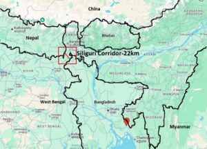
In the intricate geopolitical landscape of South Asia, few regions hold as much strategic vulnerability and national importance as India’s Siliguri Corridor. Commonly referred to as the “Chicken’s Neck,” this narrow, 20–22 km wide strip of land in North Bengal is the sole terrestrial connection between mainland India and its eight northeastern states. As regional dynamics shift—particularly involving China, Bangladesh, and Myanmar—the Siliguri Corridor has emerged as a critical concern for India’s security and connectivity strategies.
The strategic significance of the Siliguri Corridor
Geographically wedged between Nepal to the west, Bhutan to the north, and Bangladesh to the south, the Siliguri Corridor is a logistical lifeline. It provides essential road, rail, and defence connectivity to the Northeast, a region covering approximately 262,230 square kilometres—about 8% of India’s landmass—and home to over 40 million citizens.
This corridor not only supports military mobilisation but also facilitates 95% of exports from northeastern states like Assam, Meghalaya, Manipur, Nagaland, and Arunachal Pradesh. Its disruption—whether through conflict, blockade, or geopolitical tension—would severely impair access to these states and impact national integrity.

Proximity to China and rising threats
The corridor lies uncomfortably close to the Chumbi Valley in Tibet, an area where China has rapidly expanded its military infrastructure. In the event of a conflict, this proximity could enable China to sever the corridor, cutting off the Northeast from the rest of India. The situation mirrors the 2017 Doklam standoff, underlining the need for India to bolster its defences and develop alternative routes.
Adding to the challenge is China’s growing influence in neighbouring countries. Through infrastructure investments and strategic partnerships—particularly in Myanmar and Bangladesh—China is slowly reshaping the regional balance.
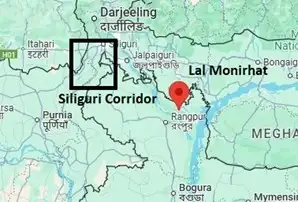
The Lalmonirhat airbase revival: A grey zone threat
One of the most recent and alarming developments is the proposed revival of the Lalmonirhat airbase in northern Bangladesh, just 135 km from the Siliguri Corridor. Originally built in 1931 and used during World War II, this airbase has remained dormant for decades. However, reports suggest renewed interest in operationalising it—allegedly with Chinese assistance. Though framed as an economic initiative, Indian intelligence views it as a potential surveillance and logistics hub for China. If developed, the airbase could enhance China’s intelligence, surveillance, and reconnaissance (ISR) capabilities near India’s strategic corridor, posing a significant threat.
Diplomatic warnings and regional tensions
Assam Chief Minister Himanta Biswa Sarma recently issued a stark warning, noting that “India has one Chicken’s Neck, but Bangladesh has two.” His comment was a pointed reminder that territorial vulnerabilities exist on both sides, and any attempt to exploit India’s corridor could provoke countermeasures. Concerns are also rising over Bangladesh’s interim government, led by Muhammad Yunus, which appears to be inching closer to Chinese strategic interests. Such a shift could further complicate India’s efforts to secure its northeastern connectivity.
The need for alternative connectivity
Given the escalating risks, India must diversify its access to the Northeast. Relying solely on the Siliguri Corridor is no longer viable. Several alternative options are already being explored or proposed:
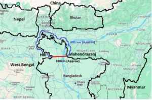
Hili–Mahendraganj transnational corridor
This proposed corridor would connect Hili (West Bengal) with Mahendraganj (Meghalaya) through Bangladesh, bypassing the Siliguri route entirely. An eight-lane expressway could be developed, offering India a faster and more secure link to the Northeast. In return, Bangladesh could receive annual transit fees—similar to the $13.6 million China pays Myanmar for its oil and gas pipeline transit.

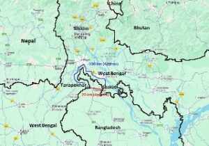
Tarapokhar–Shakati elevated corridor
An alternative approach to bypass the Siliguri Corridor could involve creating a transit route between Tarapokhar, situated on the western Indo-Bangladesh border in West Bengal’s Uttar Dinajpur district, and Shakati, located on the eastern border in Jalpaiguri district. This proposed corridor would reduce the travel distance from approximately 131 km to just 20 km, reducing dependence on the Siliguri stretch. India could draw inspiration from the Kartarpur Corridor with Pakistan—an initiative that proves even high-sensitivity cross-border projects are possible when driven by strategic foresight and diplomatic cooperation.

Subterranean infrastructure in the Siliguri Corridor
In addition to external alternatives, India could also develop underground infrastructure within the Siliguri Corridor itself. Subsurface tunnels for roads, railways, utilities, and communications would reduce exposure to aerial threats and enhance security. Global precedents exist: Japan’s Yamate Tunnel, stretching 18.2 km beneath Tokyo, and China’s 18-km Zhongnanshan Tunnel under the Qinling Mountains demonstrate the feasibility of such ambitious projects. Similar innovations in Siliguri could safeguard this critical link while ensuring continuous access, even during hostilities.
Kaladan multimodal transit corridor
Following remarks by Bangladeshi interim leader Muhammad Yunus, who described India’s Northeast as “landlocked” during a visit to China, New Delhi responded by imposing restrictions on Bangladeshi exports and accelerating alternative connectivity initiatives that bypass Bangladesh. Central to this strategy is the Kaladan Multi-Modal Transit Transport Project (KMMTTP), designed to link Kolkata with Mizoram through Myanmar. India has intensified efforts to complete the KMMTTP, which aims to provide a more direct route from Kolkata to the northeastern states. The project is already partially operational, and the Indian government is now expediting work on the remaining components.
The KMMTTP consists of three major segments: a maritime leg of about 539 km from Kolkata Port to Myanmar’s Sittwe Port; an inland waterway stretch of roughly 158 km along the Kaladan River from Sittwe to Paletwa; and a 110 km road from Paletwa to Zorinpui on the India–Myanmar border. From Zorinpui, the route connects to Mizoram and integrates with India’s existing road infrastructure in the Northeast.
A strategic imperative
The Siliguri Corridor is more than a mere passage—it is a strategic lifeline that underpins India’s unity and regional stability. With growing threats from China’s expanding presence in South Asia and potential vulnerabilities stemming from neighbouring states, India must act decisively.
Building alternative corridors through Bangladesh and Myanmar, reinforcing the existing one with advanced infrastructure, and maintaining diplomatic leverage over regional transit routes are no longer optional—they are imperative. Protecting the Siliguri Corridor and ensuring uninterrupted access to the Northeast is not just a matter of regional development, but of national survival and strategic foresight.
Disclaimer
Views expressed above are the author’s own.
END OF ARTICLE