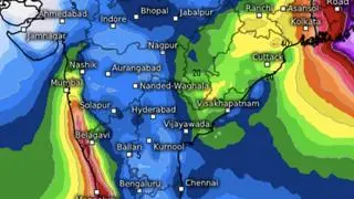
Monsoon remains stalled along Mumbai, Ahilyanagar (Maharashtra); Adilabad (Telangana); Bhawanipatna and Puri (Odisha); Sandheads and Balurghat (West Bengal) as Friday’s well-marked low-pressure area weakened into a ‘low’ this morning.
The ‘low’ lay over north-east Assam as the lone system in overall charge of monsoon, and will continue to trigger widespread rainfall over North-East India during next seven days, India Meteorological Department (IMD) said.
Isolated heavy to very heavy rainfall is likely over hills of West Bengal and Sikkim today and tomorrow; and over Assam and Meghalaya; Arunachal Pradesh; Nagaland, Manipur, Mizoram and Tripura for next seven days from a remnant circulation left behind by prevailing ‘low.’ Isolated extremely heavy rainfall is likely over Assam and Meghalaya tomorrow (Sunday), following extremely heavy rain in the region received until 5.30 pm yesterday (Friday).
Orange warning issued
India Meteorological Department (IMD) issued an ‘orange warning’ to all districts in Kerala and Lakshadweep Islands this morning. A similar warning was also issued to various districts in West Bengal, Tripura, Assam and Arunachal Pradesh. An orange warning from non-monsoon rainfall is valid also for some places in Jammu and Kashmir, which is bearing the brunt of violent weather from a western disturbance crossing from Pakistan into North-West India.
Rain for South Peninsula
Over the South, isolated heavy rainfall is likely over Coastal Karnataka for next three days, and over Kerala and Mahe for two days. Fairly widespread rainfall, thunderstorms, lightning and gusty winds are likely over Kerala, Mahe, and Karnataka for two days, and scattered over Tamil Nadu, Puducherry, Karaikal, Coastal Andhra Pradesh, Yanam, Rayalaseema and Telangana.
‘To squelch top heat’

Prof Anjal Prakash
Anjal Prakash, Clinical Associate Professor and Research Director at Bharti Institute of Public Policy at Indian School of Business (ISB), said projected above-normal rainfall (106 per cent) for the country as a whole could bring relief from intense summer heat.
June that typically sees around 166 mm of rainfall may likely see an eight-percent increase, although regional variations are anticipated. Certain areas such as the North-East may receive below-normal rainfall, potentially impacting local agriculture and water resources. Detailed at sub-division level forecasts say most other regions may witness normal to above-normal rainfall.
Forecast dissemination
Prakash called for efforts to ensure timely dissemination of seasonal forecasts and onset of rainfall to farmers, especially given regional variations. On the other hand, farmers should remain vigilant to regional differences, even as authorities focus on effective communication strategies to maximise benefits flowing from a potentially good monsoon.
More Like This

Published on May 31, 2025


https://shorturl.fm/f4TEQ